Full Case Study
Challenge(s)
Intterra’s SITUATIONANALYST Case Study Ventura County Metro Wildland Urban Interface
The Ventura County Fire Department response area covers 848 square miles, a space that’s about half the size of Rhode Island. Ventura County itself has a total land area of 1,843 square miles. Its terrain ranges from 42 miles of coastline up to an elevation of 8,831 feet at Mt. Pinos in the Los Padres National Forest.
The VCFD is an all-risk fire department that provides fire, rescue and emergency medical services in areas that vary greatly such as urban centers, coastline, farmlands and wildland. The sheer size and overall diversity of the county made it difficult to quickly and accurately map wildland fires. Often times, media outlets had faster intel about the fire than the command structure did because large Computer Aided Dispatch (CAD) and Records Management Systems had to be accessed separately. Accreditation and Standards of Cover data were becoming increasingly difficult to gather, compile, analyze, and share as well.
Results
 In SITUATIONANALYST (SA), the VCFD now has real-time collaborative mapping of a wide range of incidents all within the same system that is used by intel staff and PIO. Now everything works together seamlessly, allowing for final incident maps to be created with ease and increased publishing speed, allowing for the public to be informed of breaking news even faster. With CAD and AVL activity information integrated into the mapping system, incident and unit performance metrics are readily available for reviewing Standards of Cover and submitting accurate data for accreditation.
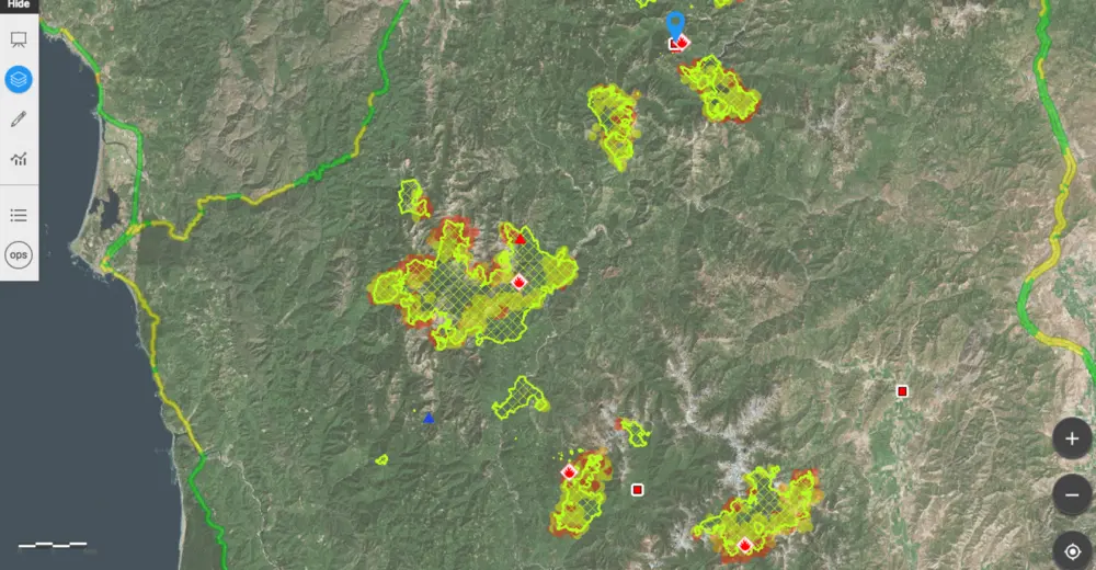
With Intterra’s SITUATIONANALYST, the VCFD now has real-time collaborative mapping of not just wildland fires but any fire or emergency response incident such as HazMat and USAR. SA provides the tools for uploading rapid field mapping, GIS maps, and PIO that allow VCFD to share relevant information with each other, partner agencies, and the public within moments of arrival on the incident scene.
Ventura has mapped their wildland preplans and fuels within SITUATIONANALYST, too. They have immediate access to operations and plans as well as to county fire history and all standard data feeds (current weather conditions, wind direction and speed, MODIS hotspots, active federal resources, and more) in SITUATIONANALYST.
In addition to wildland fire support, SA provides a live dashboard showing current incident status as well as an analysis of unit-level performance, incident metrics, and Standards of Cover. VCFD can now easily report accurate data for accreditation and other kinds of performance reporting. They know at any given moment how well they are meeting Standards of Cover and other performance benchmarks. Information is live and available to everyone on staff, resulting in a higher awareness of individual performance challenges and successes. This tends to make data a part of everyday decisions rather than just a history lesson.
SITUATIONANALYST is an end-to-end system of systems. Whether it’s sitting at the desk or utilizing a mobile device, SA allows everyone from a firefighter on the team to the Chief to have the crucial information that they need, exactly when and where they need it.